Port Tarakohe Spatial Plan adopted – Thank you for your support!
Tasman District Council has formally adopted the Port Tarakohe Spatial Plan. It sets out the intended uses of the Port and its immediate surrounds.The plan will inform zoning and guide future decision-making and development to ensure Tarakohe thrives as an integrated port and harbour and continues to serve as a hub for fishing, aquaculture, and boating.
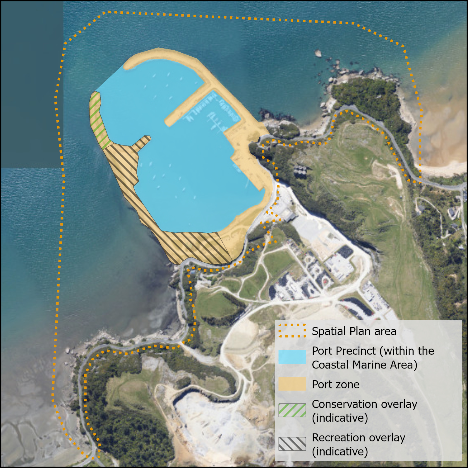
Three main objectives guide the plan.First, zoning clarity. The area within the breakwaters will be zoned Port Precinct, and the land zoned Port, with recreation and conservation overlays prioritising community spaces such as boat ramps and kororā (little blue penguin) habitats.
Second, sustainable growth considers infrastructure needs, including potable water, wastewater, and safer access along Abel Tasman Drive, supporting local businesses and resilience.
Third, protecting special values. The coastal cliffs will gain Outstanding Natural Features status, cultural assessments with iwi will enhance this taonga, and a biodiversity group will support native habitat restoration.
The plan requires further work on the bigger-picture issues like improving road safety and traffic flow on Abel Tasman Drive, making sure water supply and wastewater systems can handle future growth, and keeping the stunning coastal cliffs and wildlife safe.
The next steps include changing the zoning, creating a port management plan, developing reports on servicing, and iwi-led cultural work – all prioritised for swift action. Commercial returns will sustain operations, blending economic vitality with environmental care.
The community helped shape the Port Tarakohe Spatial Plan
The issues and options paper for the spatial plan relied heavily on past feedback from the community regarding the development of the port. This feedback was used to draft an issues and options paper which the community provided further comment on. The draft spatial plan was well supported by the community and following further consideration of the matters raised the spatial plan was finalised.
Copies of the final spatial plan and the documents used to help develop the spatial plan can be found in the Document Library on this page.
We wish to thank everyone who took the time to be involved.
Key outcomes of the Spatial Plan:
- The area will continue its current use and management, with the water space zoned as a port precinct and the land area zoned as Port through a future plan change.
- Within the Port zone area, Conservation and Recreation Overlays will be used to provide for these sub-areas of use.
- Conservation and recreational activities in these overlay areas will be given preference.
- Other special values like the coastal cliffs, will be protected through specific provisions in a future plan change.
- Commercial returns will be used to support the development and operation of the port.
- A Management Plan for the port will be prepared and consulted on.
- A servicing and traffic report will be prepared identifying options and funding.
Spatial Plan areas of use
The Port Tarakohe Spatial plan is a high-level document and as the Action Plan is worked through there will be further opportunity for users and the community to respond to the detailed proposals.
We will continue to provide updates as the implementation progresses.
Thank you to Port Tarakohe users and the Golden Bay community for your ideas and suggestions on how the Port should progress over time – you input has helped shape the framework and the actions plan which we will continue to roll out. Please keep an eye out for further opportunities to participate in the development of the port.
The purpose of the Port Tarakohe Spatial Plan is to provide a high-level planning framework that sets out intended uses of areas within Port Tarakohe and its immediate surrounds.
The Spatial Plan will be used to inform the Council’s resource management plan and any future planning documents, and to influence wider Tasman District Council (TDC) decision making in relation to Long Term Plan funding and work plans for various Council departments.
The Council decided to undertake this planning process to address the following issues:
- There is a complexity of issues, values, and interests in Port Tarakohe with competing uses and demands.
- Increasing pressures on use and development of the Port area in a wider sense merit a strategic planning response.
- To inform the Tasman Resource Management Plan review, there is a need to have appropriate background to make good decisions on zoning, rules etc that deals with the complex values, uses and land ownership pattern.
This Spatial Plan sets a direction for future activities within the Port area. Providing clear and intentional direction reduces risk of inappropriate development that impacts on the environment or the community and improves certainty for all.
Consultation
The main themes received through the feedback include:
- The commercial Port area is an important resource for supporting economic operations including marine farms, tourism opportunities and providing resilience for Golden Bay | Mohua. Port and harbour activities should be prioritised.
- Desire for increased and enhanced amenities and activities, including ablutions, seating, planting, parking, improved access, and safety, and potentially hospitality.
- The Port area is an important recreational space for passive and active recreation and there is a demand for increased recognition of and support for the full range of recreational opportunities.
- Protect the significant ecological and landscape qualities of the area including the habitat for Kororā little blue penguins, and the cliffs with their unique vegetation.


